Challenging Hiking Adventures in Norway's Sognefjord Region
Demanding and challenging trails in the mountains in Sognefjord
Introduction:
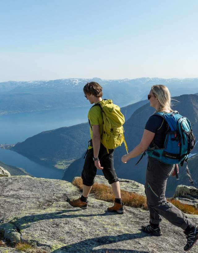
Nestled within the breathtaking landscapes of Norway, the Sognefjord region offers avid hikers a series of demanding and challenging trails that showcase the raw beauty of the Norwegian wilderness.
With day stages of up to approximately 25 km, these hikes are tailored for individuals in peak physical condition with some mountain experience. From the awe-inspiring Hovdungo Aurland to the dramatic Rimstigen Gudvangen, each trail presents a unique opportunity to immerse oneself in the rugged charm of Norway's outdoors. Since the lengt on the hikes might not look so demanding, it is always important to include the meters of hight up and down as well. That makes the hikes way more challenging.
Featured Hikes:
1. Hovdungo Aurland (6.4 km): Begin your adventure with the Hovdungo Aurland trail, spanning 6.4 km. As you traverse this challenging route, marvel at the stunning landscapes overlooking the world famous Aurlandsfjord that set the tone for the extraordinary hiking experiences awaiting you
2. Rimstigen Gudvangen (4.4 km): The Rimstigen Gudvangen trail, spanning 4.4 km, beckons with its allure and demands your utmost determination. Navigate through diverse terrains and relish the sense of accomplishment as you conquer this steep and challenging section. The price is the overlook over the UNESCO listed Nærøyfjord all the way from start to top.
3. Keipen Balestrand (8.9 km): Explore the Keipen Balestrand trail, an 8.9 km stretch that promises panoramic views and a true test of your hiking prowess. As you ascend, the awe-inspiring vistas unfold, rewarding your efforts with the unparalleled beauty of the Sognefjord region.
4. Vettisfossen Upper Part waterfall - Årdal (21 km): Engage with the challenging upper part of the Vettisfossen trail, a testament to Norway's untamed wilderness. Amidst the rugged terrain, the thundering sound of waterfalls accompanies you on your exhilarating
This trail takes you to the top of the majestic Vettisfossen waterfall, one of Norway's highest waterfalls. In Utladalen valley Årdal. The hike in the Utladalen shows you as well many other amazing waterfalls along the hiking road.
5. Raudmelen Balestrand (7 km): The mount Raudmelen in Balestrand trail invites you to conquer its heights and revel in the stunning vistas that unfold along all the way. This challenging ascent promises not only physical exertion but also a profound connection with Norway's natural wonders. And you will get a stunning view all the way from start to the top.
6. Flatbrehytta - Fjærland (6.7 km): Traverse the trail to Flatbrehytta in Fjærland, experiencing the diverse landscapes that characterize this region. Your stamina and determination will be put to the test as you navigate through challenging terrains and unpredictable weather conditions. At the top you will be premiered the most stunning fjord view at the edge of the glacier. The combination of blue ice and the fjord landscape is quite unique. And it is one of the favorite hikes to the Queen of Norway. We understand why.
7. Prest - Aurland (5 km): The Mount Prest (Priest) trail, spanning 5 km, offers a mix of challenging ascents and descents. Embrace the physical demands of this trail and savor the moments of triumph as you conquer each segment. The top point is over 1400 Masl. but the starting point is at around 800 Masl. from the parking lot. The view shows the whole Aurland fjord!
8.
Mælen - Leikanger (5.3 km): Conclude your journey with the Mælen - Leikanger trail, who stretch that demands your energy. As you complete this hike, reflect on the challenges overcome and the stunning landscapes witnessed throughout your hiking adventure overlooking the Sognefjord in 180 degrees wide.
Preparation and Tips:
Before embarking on these demanding hikes, meticulous preparation is crucial. Ensure you possess suitable gear, including a reliable pair of hiking boots, weather-appropriate clothing, and a well-packed rucksack with essentials such as water, snacks, and a first aid kit. Familiarize yourself with the marked routes, and carry a map for added navigation. Given the seriousness and difficulty of these hikes, they are exclusively recommended for experienced hikers.
Conclusion:
Immerse yourself in the magic of Norway's outdoors with these challenging day hikes in the Sognefjord region. Whether conquering the heights of Keipen Balestrand or marveling at the Vettisfossen waterfall, each adventure promises a glimpse into the natural wonders that make Norway a hiker's paradise. As you embark on your journey, let the Sognefjord region be the backdrop to an unforgettable hiking experience.
Happy Hiking!
Join in & follow us on Instagram
The Norwegian Mountain Code
The Norwegian Mountain Code (called "Fjellvettreglene" in Norwegian) is directed towards your safety.
1. Plan your trip and inform others about the route you have selected.
- Plan your trip based on the group’s abilities, and always include alternative options.
- Obtain current information about the area and the weather conditions. Listen to the advice of seasoned mountaineers where possible.
- Ensure you have sufficient knowledge and practical skills to complete this trip.
- Respect the natural environment. Plan ahead and do not leave any litter behind you.
- Arrange meeting points during the trip that don’t require mobile coverage or accurate timing.
- Is your planning sufficient to guarantee an enjoyable trip no matter what?
2. Adapt the planned routes according to ability and conditions.
- Assess the conditions continuously and adjust your plans accordingly.
- Respect the weather!
- Travelling with others is safer and means you will have someone to share your experiences with. If you’re travelling alone, exercise caution.
- Do not embark on a long trip without sufficient experience. You must be able to take care of yourself as well as the others in your group.
- Be considerate of other hikers. Make sure you have read The Right of Access and its requirements.
- Make sure your group maintains an open and direct line of communication at all times.
- Can you complete the trip under these conditions and with this group?
3. Pay attention to the weather and the avalanche warnings.
- Always check the weather forecast and avalanche warnings to see what impact they have on the area. Follow the advice and choose a gentler terrain when conditions are too demanding.
- Check the conditions on yr.no, storm.no and varsom.no.
- Monitor the development of the weather and avalanche conditions along the way. Bear in mind that plans may need to be adjusted.
4. Be prepared for bad weather and frost, even on short trips.
- Dress appropriately for the weather, and the terrain.
- Remember that the weather changes quickly in the mountains. Bring extra clothing, and the equipment your route and terrain requires.
- Extra food and drink can help save lives, if the trip takes longer than planned or you have to wait for help.
- Is your group equipped to deal with a sudden change in weather?
5. Bring the necessary equipment so you can help yourself and others.
- In the winter, you need a windsack/bivy sack, sleeping pad, sleeping bag and a shovel so that you can spend the night outdoors if you have to. A windsack can save lives.
- Bring a high-visibility vest or a headlight, that will make it easier to find you if necessary.
- Bring a first aid kit so you can help yourself and others.
- Always use a transmitter/receiver, and have an avalanche probe and a shovel if you are traveling in avalanche prone terrain.
- Pack smart! Packing lists for different tours can be found at ut.no.
- Mobile phones can be a useful tool, but remember that they do not work in all situations and areas.
- If an accident occurs, alert the police at 112, go for help or try to notify someone with other means.
- Are you able to take care of yourself and help others?
6. Choose safe routes. Recognize avalanche terrain and unsafe ice.
- Take an active decision to avoid terrain that is prone to avalanches, and plan your route well.
- Be aware that avalanches can start in drops higher than five meters and steeper than 30 degrees.
- Even if you walk in flat terrain, you can trigger an avalanche on the mountainside above you.
- An avalanche dropout zone can be three times the height of the drop.
- Avoid terrain traps, such as narrow gorges. Consider what will happen if there is an avalanche.
- Be aware that a cornice can break off when you walk on a mountain ridge.
- Be aware of ice conditions when you walk on regulated lakes and rivers.
- Can an avalanche happen where I plan to go? What will the consequence be?
7. Use a map and a compass. Always know where you are.
- A map and compass are an essential basic equipment that always work.
- Pay attention to the map even when hiking on a marked trail.
- Knowing where you are on the map, makes for a better hiking experience.
- GPS and other electronic aids are helpful, but make sure you have extra batteries.
- Do you know where you are?
8. Don’t be ashamed to turn around.
- Evaluate your route continuously and if conditions are becoming difficult, choose your best alternative long before you or group members become exhausted.
- Have the circumstances changed? Should you turn around?
- Is anyone in your group have problems completing the route? Should the group turn around?
- Enjoy the hike for its own sake, and remember that there will be other opportunities if it is too challenging today.
9. Conserve your energy and seek shelter if necessary.
- Adjust your hiking speed to the weakest member of the group, and make sure that everyone can keep up.
- Remember to eat and drink frequently. When you exert yourself, your body needs more fluids than you may feel you need.
- Don’t wait until you are exhausted before you seek shelter. Strong winds will tire you out quickly.
- Use your windsack or dig a snow cave before it’s too late.
- Are you able to get back to your base? Do you know where the nearest shelter is?


